
Suddenly! The building subsidence incident sounds the alarm again!
How does millimeter level monitoring provide insurance for urban building safety?
At 4:50 pm on June 16th, a 4-story self built building in a certain district of Shenzhen suddenly made a loud noise. The roar was like an earthquake, "recalled the residents at the scene. The wall of the building has torn a 2-meter-long crack, which can be penetrated by fingers. The building is visibly tilted. The government urgently evacuated 783 residents from 25 buildings and mobilized 50 inspectors to set up 95 monitoring points for 24-hour duty. It is worth noting that a truck pit accident occurred in the same area 600 meters away in March last year, and a 3-meter deep road collapse also occurred 2.5 kilometers away in January this year.
Invisible Crisis "- How can millimeter level deformation destroy a building?
The building that experienced settlement this time had cracks spreading upwards from the foundation, which is precisely why Typical characteristics of cumulative deformation.
Traditional monitoring blind spots: Manual inspection cannot identify the initial stage Millimeter displacement (such as annual settlement of 1-2mm);
Explosive deterioration: After the soil becomes saturated with water during the rainy season in Shenzhen, small cracks may expand tenfold within 72 hours;
Cost black hole: This incident alone has mobilized 95 monitoring points and a team of 50 people, resulting in a loss of over 10 million due to lockdown measures.
Self built houses in urban villages - the 'grey rhino' of urban safety
At the same time, this building is also a typical self built house without standardized design:
Weak foundation: Without geological exploration, directly built on backfill soil, weak geology is prone to uneven settlement;
Density fatal: The density of self built communities is high, with building spacing of less than 2 meters, and single building settlement can easily trigger a chain reaction;
Monitoring vacuum: The disease has been developing for a long time, and turning a blind eye to the hidden dangers exposed for a long time, the monitoring vacuum is the true source of the disaster.
Monitoring plan for the 'Land God' in MINTAIAN: Three layer defense system broken through
Sky ground integrated network based on InSAR technology+unmanned aerial vehicle LiDAR+AIoT warning
1、 Technical core: Accurate empowerment of three-dimensional monitoring system
Based on mature urban building safety emergency experience and technical system, MINTAIAN has constructed a set of coverage through multi-source data fusion and layered empowerment A three-dimensional monitoring system for macro, meso, and micro areas and buildings. At the macro level, InSAR synthetic aperture radar interferometry technology is used to analyze the phase difference of satellite radar images in the same area at different times, achieving all-weather monitoring of millimeter level ground subsidence and building deformation at the city level; At the meso level, unmanned aerial vehicle (UAV) airborne laser point cloud technology is used to conduct multi-stage scanning of high-risk areas, establish three-dimensional models, and quantify settlement amplitudes with centimeter level accuracy; At the micro level, monitoring is combined with oblique photography 3D reconstruction and digital twin archives, supplemented by a risk sensing system, to capture the millimeter level deformation and environmental parameters of individual buildings in real time, build a closed-loop warning system, and comprehensively empower urban safety management.
2、 Monitoring scenario: practical application of full-scale risk prevention and control
1. Macro regional monitoring
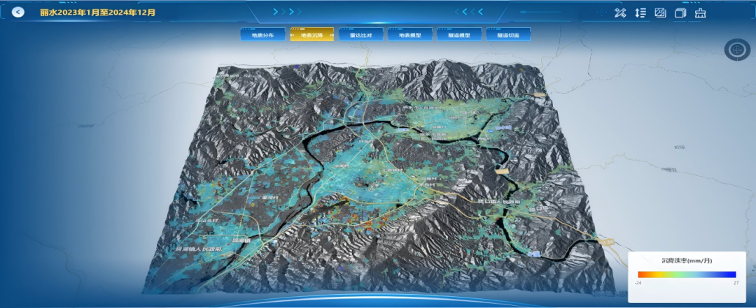
For urban areas or high-risk areas of geological disasters, MINTAIAN uses InSAR technology for large-scale settlement trend analysis, with an accuracy of up to millimeter level, wide monitoring coverage, all-weather operation, and no meteorological impact.
Image acquisition: Regularly obtain multi track radar images, covering target cities or high-risk zones;
Phase difference analysis: Perform phase unwrapping and differencing on images at different times to extract small displacements of the ground and structures;
Time series modeling: Build a trend model based on historical data to identify continuous accumulation or new deformation;
Risk zoning and warning: Based on deformation rate and threshold rules, delineate high-risk areas and trigger macro warnings.
Application cases: MINTAIAN completed a comprehensive survey of surface subsidence in the entire Lishui area, extracted historical elevation data (January 2023 December 2024) for phase difference analysis, and formed a subsidence distribution map.
2. Screening in the Middle Range Area
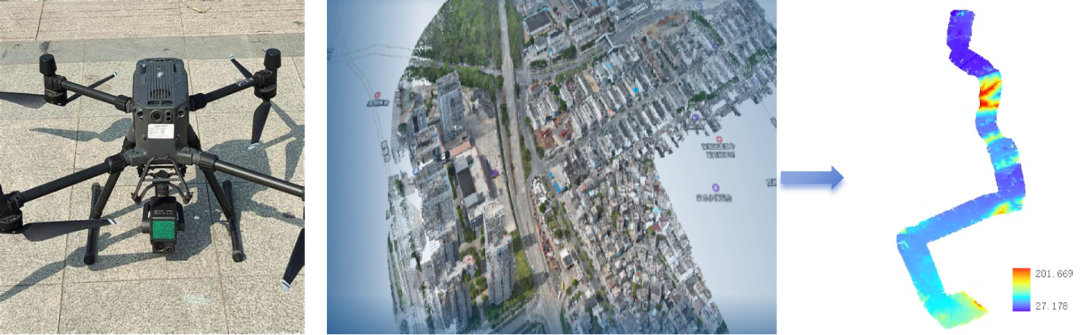
For key areas such as subway lines, under construction projects, and old residential areas, MINTAIAN uses laser point cloud 3D modeling to regularly or on-demand set up routes, achieving high-density point cloud collection. By comparing models between different voyages, regional settlement gradients can be quickly identified.
High precision airborne LiDAR data acquisition: Using drones equipped with multi echo LiDAR to obtain three-dimensional point clouds with a resolution of up to centimeters.
Multi period point cloud registration and change detection: Using ICP algorithm, voxel filtering, ground extraction and other methods, high-precision alignment and difference analysis of point clouds at different time points are carried out.
Deformation extraction and modeling analysis:
Surface subsidence analysis: Calculate the elevation changes of the same surface location over multiple periods and generate subsidence contour maps;
House deformation analysis: Extract changes in the point cloud of the building structure, identify deformation trends, tilt degrees, and cracking risks.
Intelligent risk assessment and graph output: Combining GIS system to output risk layers, variable graphs, and monitoring reports.
Application cases: MINTAIAN conducted periodic laser point cloud scanning on the surface and buildings above a certain subway line in Shenzhen, classified and compared the point cloud data, and formed a distribution map of surface subsidence along the line and a distribution map of deformation risk of surrounding buildings.
3. Microscopic building monitoring
For high-risk individual buildings, MINTAIAN achieves millimeter level real-time monitoring and early warning of foundation settlement, crack propagation, and tilt deformation through digital twin modeling, infrared wall detection, and multi-dimensional IoT sensing.
Digital twin filing: For high-risk individual buildings (such as self built houses and key buildings in old residential areas), MINTAIAN uses drone oblique photography to obtain multi angle images, generate high-precision 3D models, establish digital twin archives, and form a visual interactive interface.
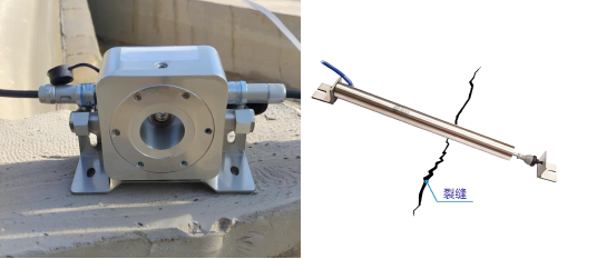
Risk sensor system:
Settlement sensors, static level gauges, wireless crack gauges, and wireless tilt sensors monitor foundation settlement, crack propagation, and overall tilt;
Rain gauges and temperature, humidity, and pressure sensors collect environmental variables to provide background data for deformation analysis;
The edge computing gateway realizes local data preliminary processing and anomaly detection to ensure data reliability and low latency.
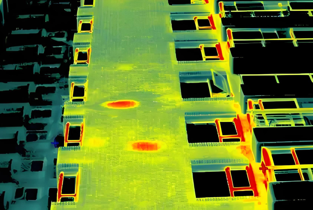
Wall infrared monitoring: In response to the hidden dangers of high-risk single building walls, MINTAIAN uses unmanned aerial vehicle mounted infrared thermal imaging to regularly scan the building in all directions, and uses AI visual recognition technology to quickly analyze wall leakage, shallow cavities, cracks and other diseases.
Multi dimensional monitoring and early warning:
Security guarantee and prevention: Real time monitoring around the clock to accurately capture anomalies such as building tilting, cracks, and settlement. Based on thresholds and intelligent algorithms, timely warnings are issued to ensure early prevention on site;
Data driven and scientific decision-making: Monitoring data is aggregated in the cloud, visualized on a large screen and displayed synchronously with mobile apps. It supports multi-dimensional analysis such as settlement cloud maps, crack propagation maps, and inclined profiles, providing quantitative basis for maintenance, reinforcement, renovation, and upgrading;
Full lifecycle management: Digital twin archives are linked with real-time data, supporting automatic generation of building safety assessment reports, assisting daily operations and emergency response, and building a long-term monitoring and risk management loop.
3、 Service value: Empowering the entire chain from data monitoring to security decision-making
Accurate early warning: By combining millimeter level monitoring and intelligent algorithms, early detection of anomalies such as settlement, cracks, and tilting can be achieved, and early warnings can be issued to effectively prevent problems.
Asset Health Monitoring: By using digital twins and multi-source data fusion, real-time monitoring of building structural changes and settlement dynamics can be achieved, providing scientific basis for maintenance, reinforcement, and structural optimization, and extending the service life of assets.
Efficient collaboration management: The visual decision-making platform integrates multi-source data and automated reports to achieve information sharing and coordinated command among multiple departments, improving emergency response speed and management efficiency.
Empowering decision-making intelligence: Based on big data analysis and visualization trend insights, provide accurate data support for urban planning, ongoing projects, and operation and maintenance management, and promote scientific and intelligent decision-making.
Sustainable risk closed-loop: The closed-loop mechanism of full cycle monitoring and risk assessment covers pre disaster monitoring, mid disaster warning, and post disaster assessment, helping to build a long-term urban disaster prevention and reduction system.
Business contact: Manager Wang 19926659982
 WeChat official account
 WeCom
WeCom